
Your first thought upon hearing the name India is probably that our country is a multicultural nation with an interesting past. It is known for its vibrant traditions, delicious cuisine, and beautiful landscapes. Our country has made significant contributions to literature, art, and spirituality. Our people were warm and hospitable, and its festivals and celebrations were a sight to behold.

This chapter will teach us about the geographical characteristics of our country India.
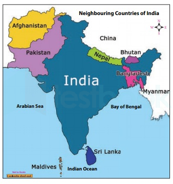
LOCATION OF INDIA
India is entirely located in the north-eastern hemisphere. We can confirm that by the latitude and longitude of our country which are 8°4'N and 37°6'N latitudes & 68°7'E and 97°25'E longitudes. On the longitudes, we have a time lag of 2 hours between 68°7'E and 97°25'E. If India is divided into halves by the tropic of cancer (23° N). 82°30'E has been taken as the Indian Standard Time. This meridian or longitude is also termed the Standard Meridian of India.

- Afghanistan
- Pakistan
- China
- Nepal
- Bhutan
- Myanmar
- Bangladesh
- Srilanka
POLITICAL AND ADMINISTRATIVE DIVISIONS IN INDIA
India consists of 28 states and 8 union territories.
You can refer to our government website, https://knowindia.india.gov.in/states-uts/

PHYSICAL DIVISION OF INDIA
India is marked by a diversity of physical features such as mountains, plateaus, plains, coasts and islands.

We have 6 physiographic divisions in our country India.
- The Himalayan Mountains
- The Northern Plains
- The Peninsular Plateau
- The Coastal Plains
- The Indian Deserts
- The Islands
The Himalayas
Three major parallel ranges comprise the Himalayan Mountain range. Great Himalayas, also known as Himadri, are the northernmost. Within this range are the highest peaks on Earth. Beyond Himadri is the Middle Himalayas, often known as Himachal. To the south lies the Shiwalik range.
The Northern Plains
The Northern Indian plains lie to the south of the Himalayas. They are generally level and flat. These are formed by the alluvial deposits laid down by the rivers– the Indus, the Ganga, the Brahmaputra, and their tributaries. These river plains provide fertile land for cultivation. That is the reason for the high concentration of population in these plains.
The Indian Desert
In the western part of India lies the Great Indian Desert. It is a dry, hot, and sandy stretch of land. It has very little vegetation.
The Peninsular Plateau
The Peninsular Plateau lies south of the Northern Plains. It has a triangular form. Extremely uneven relief is present. There are many valleys and hill ranges in this area. Its northwest boundary is bounded by the Aravali Hills, one of the oldest mountain ranges. The two major ranges are the Vindhyas and the Satpuras. These ranges are traversed by the Narmada and Tapi rivers. These are west-flowing rivers that drain into the Arabian Sea.
The Ghats
The plateau is bounded on the west by the Western Ghats, also known as the Sahyadris, and on the east by the Eastern Ghats. The Eastern Ghats are uneven and broken, whereas the Western Ghats are nearly continuous. Minerals such as iron ore and coal are abundant on the plateau.
The Coastal Plains
The Coastal plains lie east of the Eastern Ghats and west of the Western Ghats. It is very narrow in the western coastal plains. Much wider coastal plains can be found in the east. Numerous rivers flow towards the east. The Bay of Bengal receives water from the Godavari, Krishna, Kaveri, and Mahanadi rivers. At their mouth, these rivers have created productive deltas. The Sunderban delta is formed where the Ganga and Brahmaputra flow into the Bay of Bengal.
The Islands
India is also made up of two groups of islands. Within the Arabian Sea are the Lakshadweep Islands. These coral islands are situated off Kerala's coast. The Andaman and Nicobar Islands are in the Bay of Bengal to the southeast of the Indian mainland.
Thank You