
In this chapter, we will learn about our globe's latitude and longitude of the Earth.
Did you know?
Our Earth is 23.44° tilted.
If you draw an imaginary line straight through the north and south poles is called an AXIS.

LATITUDES
Circles drawn parallel on Earth are called LATITUDES.

EQUATOR is a reference line which divides the earth into 2 equal halves known as the North and South hemispheres.
There are 5 important parallels of latitudes.
The most noteworthy parallels are the North and South Poles, the Tropic of Cancer, the Tropic
of Capricorn, and the equator.
- Equator represents the zero-degree latitude.
- Tropic of Cancer, representing 23 ½°N.
- Tropic of Capricorn representing 23 ½°S.
- The North Pole representing 66 ½°N.
- The South Pole representing 66 ½°S.
The North and South of the Equator zone are called TORRID ZONE.
The area between the North Pole and Tropic of Cancer, South Pole and Tropic of Capricorn are known as TEMPERATE ZONES.
The area of the North and South Pole is known as FRIGID ZONE.
As the earth is tilled and geoid as a the sun's rays will not fall straight on the Earth.
The temperature decreases from the equator to the poles.
Therefore, the Equator is always hot, and the poles are always cold.
LONGITUDES
Reference lines which are drawn from the north to South pole are called LONGITUDES.
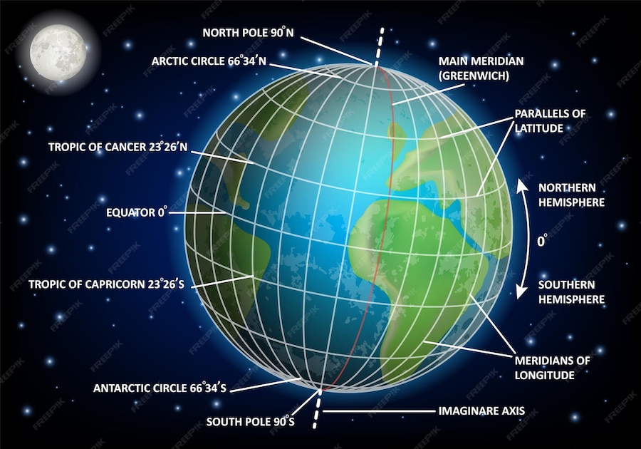
These lines are also called meridians of longitudes.
The distance between them is measured in degrees of longitude.
Furthermore, the equator is the zero-degree latitude which divides the earth into 2 equal halves.
Longitude plays an important role as it determines the time for each country.
But did you know where the longitude will start?
All countries decided to count the longitude which passes through Greenwich where the British Royal Observatory is located as the 0° Meridian. This Meridian is called as Primary Meridian.
This Primary Meridian will divide the earth into 2 equal halves as eastern Hemisphere (180°) and the Western Hemisphere (180°).
Both latitude and longitude are mandatory to calculate the position of a country.
Finally, let's find out the time for our country.
STANDARD TIME OF A COUNTRY
Standard time is a system where a whole country will follow a particular time.
India's time zone as per Greenwich is +5.30
Let us assume,
If we want to know the time of the USA,